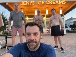
I’m just here so I don’t get fined… #Shield
Date: 2025-07-24 AO: shield Q: tagalong PAX: ToeJam, shrinkwrap FNGs: None COUNT: 3 “I’m just here so I don’t get fined…” — Marshawn Lynch, probably talking about this Slackblast.
Apparently it’s “vacation week,” but the real ones don’t take PTO from greatness. 3 PAX showed up to punch the time clock:
– tagalong – running the show like BeastMode in the red zone – shrinkwrap – too sticky to cover in the 3-cone drill – ToeJam – silent but deadly, like a skittle in Marshawn’s sock
We hit the parking lot hard: :fire: Combine-style 3-cone drills :fire: Fan belt resistance circuit :fire: Booty bands for the ladies :fire: Jump ropes flailing like contract extensions
No clipboard. No excuses. Just work.
If you missed it, that’s between you and Bombay. #BeastMode #ShieldStrong #IAmOnlyPostingSoBombayDontYell
When a Meathead plays with SACs
Date: 2025-07-23 AO: sacs Q: Unplugged PAX: Cheese Curd, Dora, geraldo, Roulette FNGs: None COUNT: 5 WARMUP: ummmm….these weirdos drove in with rucks on, so I assume that warmup is not a thing. off to the regular thang……sorry SSH, LSS, and Prying squat
THE THANG:
Thang #1 – Sandbags and Rucks On ABC-D ABC = Armor Building Complex a kettlebell standard for strong anaconda muscles….aka strong like bull. – 2 SB Cleans – 1 SB Press – 3 SB Front Squats
D= Drag -while 4 of the Pax did above the other PAX dragged a tire filled with his sandbag. Rest of the PAX then chased him. Next man up! Each PAX pulled the tire 2x. We did 10 rounds of ABC.
I was gassed and asthma kicked….that means it’s a good workout.
Note: Roulette Does not listen or is off in the head or is an $%$hole (all 3?) ’cause he ran away with the tire downhill. Thus causing the rest of the PAX pull it back up hill. In retrospect, I like his style.
Thang 2: Go Away and Come Back PAX carries SB w/Ruck 25 meters (aka to geraldo car) and back. Rest of PAX do the following (rucks on): – Plank pull throughs – Ground to Shoulder (alt) – Rows – slow eccentric – Merkins (on bag) – Good Morning Completed this for 3 rounds. Mixed up the order to allow all the Pax a taste of the exercises.
Thang 3 – 8 Min of Hell EMOM w/SB (slick or ruck) Deadlift Row C&P Push Press Reverse lunge Single leg deadlift Burpee Plank Thruster Note: I warned the stubborn Pax to do this slick. Some listened, some mod. later, and others (ahem Cheese Curd) kept the ruck on and just cussed me. Success!
Time to bring tire sled back to my new-to-me Subie.. We loaded all the SBs in a the tire ~300lb? team dragged it back.
Burn the rest of the time with a light stroll around the parking lot and some mary.
MARY: Boat/Canoe American Hammer Pretzel Crunch Glute Bridge Plank ANNOUNCEMENTS: Run/ruck on some hills on a hot day. COT: YHC took us out.
Thanks for the opportunity/shaming/voluntold to Q. See you in 3-6 months.
-UP
That was excessive
Date: 2025-07-23 AO: meathead Q: voodoo PAX: Emoji, Fotomat, Uncle Leo, high_tide, taggart, flipper, voodoo FNGs: None COUNT: 7 YHC pulled up “early” (according to High Tide) around 0522 to get my Ozzy playlist ready. Uncle Leo and Flipper were already there, warming up and we were joined by the aforementioned High Tide and Emoji before 0530. Foot mat was a few minutes later and Taggart strolled in about 10-15 minutes late, as is his custom.
WARMUP: SSH, IW, ST, synovial circles, prying squat
THE THANG: 30:00 EMOM of the Armor Building Complex, which was pretty brutal. Static holds (doubles): overhead, racked, waiter for :20 each with 1:00 rest between the two sets.
MARY: anchored leg raises x 10 OYO, elbow plank, hollow body hold, glute bridge (because we hadn’t worked out posterior chain enough)
ANNOUNCEMENTS: Horsey half/ruck on 8/2 at 0600. Dads’ Camp 8/15-8/17 at Camp Thunderbird
COT: the Anvil lax (led by Mr. Magoo) joined us and Flipper took us out.
Three Amigos
Date: 2025-07-23 AO: _area-51 Q: Mr. Magoo PAX: Point Break, lorax FNGs: None COUNT: 3 WARMUP: The usual at the oval. THE THANG: Started with the circle of rocks, a lap of curling, a lap of pressing, and a lap of triceping around the circle with a rock. Then off to the north parking lot for three laps of four exercises, merkins, LBCs, wide arm merkins, and heels to heaven. Next to the hot house for three sets of step ups, dips, and inclined merkins with a run in between around a light post. Followed by more rocks near the cricket field and finished with Voodoo and the Meatheads. MARY: Yes, see above. ANNOUNCEMENTS: Yes, Lorax is building a pool and Point Break is coupling at the Grand Bohemian in Greenville while the kids are at camp. COT: Flipper closed us out with the Meatheads.
Providence Hill Suckage
Date: 2025-07-22 AO: fast-twitch Q: retread PAX: Astro (Kyle Kirchhoff), Benny, Alf, retread FNGs: None COUNT: 4 WARMUP: Astro-approved 1.25 mile warmup to Greyson Ridge Dr. THE THANG: Repeats on the long, grinding behemoth known as Providence Hill Suck on Strava, dodging the random mound of grass and dirt near the start. Astro (Kyle Kirchhoff) Alf led the way with 4 trips up and back. ANNOUNCEMENTS: Horsey Half is fast approaching. COT: Astro.
Summer Heat
Date: 2025-07-22 AO: bagpipe Q: teddyf3 PAX: Roulette, goat, Blue Tent, taggart FNGs: None COUNT: 5 WARMUP: Short mosey to pick up taggart at his car at 5:31 and on to warmup: SSHX20 MerkinsX5 IWX10 MerkinsX5 WindmillX10 MerkinsX5 PPX10 MerkinsX5 THE THANG: Mosey to sushi place for 3 sets of 4 corners. Merkins, lunges, Mary, Carolina dry-dock,calf raises, squats and more – 20 reps Mosey to pond for work at each building. MARY: Lots ANNOUNCEMENTS: help Kirby with race COT: I took us out. Prayers for Madison’s work colleagues son and Goats 3rd kiddo on the way!
Globe vs. Map
Date: 2025-07-22 AO: 3rdf-timekeeper Q: bratwurst PAX: Franky, Roulette FNGs: None COUNT: 3 As Roulette said, this Chapter is a “warning” about how to use the mental models. A Map (each Mental Model) is a representation of the underlying territory, so you need to be aware of its limitations, assumptions, and be open to feedback when applying it.
bratwurst brought the visuals – a Globe and a Map (Mercator projection). Some comparisons –
A globe accurately represents the Earth’s surface, maintaining correct proportions and shapes, while a Mercator projection is a flat map that distorts these properties, especially near the poles. The Mercator projection is useful for navigation because it preserves compass directions as straight lines, but it significantly exaggerates the size of landmasses far from the equator. [1, 2, 3]
Here’s a more detailed breakdown:
Globe: True Representation: A globe is a three-dimensional model of the Earth, accurately depicting the relative sizes and shapes of landmasses and oceans according to National Geographic Society. [1, 1, 4, 4, 5, 6] Distortion-Free: It minimizes distortion, allowing for accurate measurements of distances and directions. [1, 1, 5, 5] Ideal for Understanding Earth’s Shape: Globes are excellent for visualizing the Earth’s spherical nature and understanding spatial relationships between different locations. [1, 1, 5, 5] Limited Practicality for Navigation: While accurate, globes are cumbersome for practical navigation at sea. [1, 1, 7, 7]
Mercator Projection: Cylindrical Projection: The Mercator projection maps the globe onto a cylinder, which is then unrolled into a flat map. [8, 9] Directional Accuracy: It preserves compass directions as straight lines (loxodromes), making it useful for navigation. [3, 10] Area Distortion: The projection distorts the size of landmasses, especially at higher latitudes. For example, Greenland appears larger than South America, even though it’s much smaller according to Atlas.co. [2, 11] Misleading Perception of Size: The Mercator projection can lead to a skewed understanding of the relative sizes of countries and continents. [2, 12] Useful for Navigation: While area is distorted, the Mercator projection is still valuable for nautical navigation because it allows for straight-line courses to be plotted on the map. [3, 7]
NEXT 3 WEEKS ARE BOOKED: 7/29/2025 Hippie: Circle of competence 8/5/2025 Franky: First principles thinking 8/12/2025 Citgo: Thought experiment
Space Needle – Liftoff
Date: 2025-07-22 AO: swift Q: bratwurst PAX: flipper, voodoo, Wolverine, fleetwood, gumbo, Franky, kirby, madison, tagalong, midriff FNGs: None COUNT: 11 WARMUP: PAX left on time (sans Q) — down to R on Bally Corp, Harney, Rushmore, out to Synchrony lot. Dynamic exercises.
THE THANG: Working Interval = Run UPHILL for the full hill distance from the bottom of Ballantyne Commons up to Costigan Park. No time limit today. This is you vs. you, but feel free to start each one with a buddy. Recover back down. With the recovery distance = the working interval distance, the working interval will be at a harder effort than last month’s workout that used this section.
Most PAX got in at least 4. Some 5, plus some extra “Mount St. Durant” (the steepest part from Ballantyne Commons up to Costigan Park).
flipper consistently led and kept the recovery moving faster than anyone else. voodoo fresh off training camp in the Alps earlier in the summer was biting at his heels along with a Wolverine biting at his heels. Then the duo of gumbo and fleetwood traded places on their 5 hills, and had a tagalong with tagalong fighting up each one behind them. midriff was lost in the middle, front, and back, doing his own version at times, but kept it moving. kirby Franky madison sweated in out, perhaps played in the sprinklers (cause how wet can you get?), and kirby reminded everyone how proud he was of each guy just being there.
flipper picked up the Local Legend, but frasier KOM is still safe.
ANNOUNCEMENTS: Horsey Half Marathon early August.
COT: teddyf3 took us out
There will be blood
Date: 2025-07-22 AO: falcon-crest Q: MARTA PAX: Huddle House, puddin_pop, deep_dish, Snuka, ChickenWing, Emoji FNGs: None COUNT: 7 MUMBLECHATTER: Quite frankly I didn’t hear much of it over gasping for air. The great thing about it being 75 degrees at launch is that you don’t even need to run to start the cooling process. Farewell to Emoji for a few weeks as he parties with his 80 +yr in the Catskills and lives his best life in Manhattan.
It was a bloody one as @huddle_house cut his forehead on the bridge railing. Wanting sympathy or neighborhood solidarity, pudding drew blood somehow picking up his rock.
About 2.4 miles in the heat felt like more.
THE THANG Mosey to church 15X SSH 15X IW 10X LSS 20X LBCs
Mosey to Carmel green 5 burpees Mary
Mosey to Mcandrew for a circuit of cul de sacs
1st sac x3 Partner up 20 merkins and lbcs
Next sac x2 20 squats And Freddy
Mosey to bridge Dips x20 Inclines x10
Rockwork 3x Merkin (merkin deadlift, merkin curls, merkin press) Fluttee press x 10 10 lunges es
ANNOUNCEMENTS Orange whips half marathon thing August 20 – community matters 5k Blood drive Oct 20
CoT Yhc

It was hot ……
Date: 2025-07-21 AO: firestarter Q: Franky PAX: taggart, Roulette, Point Break FNGs: None COUNT: 4 WARMUP: short run followed by 15 SSHs, imperial walkers, windmills, and dynamic stretching THE THANG: mosey to the area behind the stores/target. 5 wall climbs. Then 7 merkins at every other street light, 10 American hammers, 7 Romanian deadlifts. Mosey to the yoga studio. 3 rounds running up with merkins and American hammers at each side. MARY: mosey to the fitness studio. Some Supermans and some stretching. ANNOUNCEMENTS: COT: